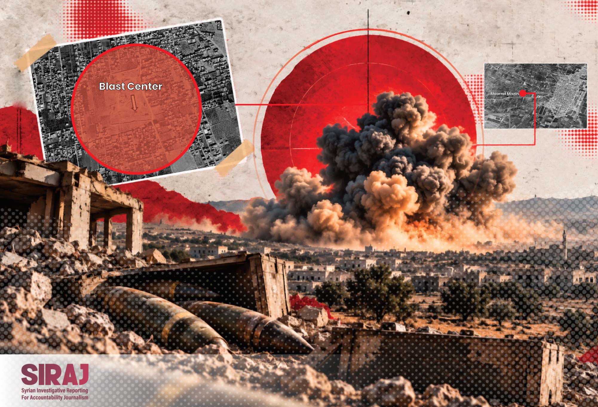


On the night of September 21, a massive explosion rocked the town of Al-Eis in the southern countryside of Aleppo. Initial reports indicated that the blast occurred at a military facility containing ammunition belonging to the Syrian Ministry of Defence.
In a brief statement, Asim Ghalioun, Director of the Media and Communications Department at the Syrian Ministry of Defence, said that “the ministry is continuing its investigations into the explosions that have occurred at several military sites, most recently at a weapons storage facility in the town of Al-Eis.”
Meanwhile, the Ministry of Emergencies and Disaster Management confirmed in a statement that people had been injured as a result of the explosion and smoke inhalation.
This was not the first explosion of its kind in Syria. Since 2025, the country has experienced at least ten similar incidents associated with the storage or transportation of weapons. These explosions have killed dozens and injured hundreds of people in civilian areas near the blast sites.
This investigation by the Syrian Investigative Reporting for Accountability Journalism (SIRAJ) examines explosions at weapons and ammunition storage facilities across Syria. It analyses the geographical locations of these incidents, assesses the risks posed to surrounding civilian areas against internationally recognised ammunition storage standards, and examines the potential consequences of similar incidents for civilian communities across the country.
Using recent Sentinel satellite imagery and infrared imaging techniques, the investigation team was able to identify damage caused by several explosions. Areas affected by fires resulting from the blasts appear in dark grey, while newly flattened surfaces, such as those left by collapsed buildings, appear in shades ranging from white to off-white.
A Series of Explosions
Less than a year after the fall of the Assad regime in December 2024, an explosion occurred at an ammunition depot in the Al-Nayrab camp area of Aleppo on July 11, injuring four people.
On July 24, 2025, another explosion struck a weapons and ammunition warehouse in Maarat Misrin, Idlib governorate. According to figures released by the Syrian Ministry of Health, the blast killed at least 11 people and injured 157 others.
On September 22, the Syrian Ministry of Defence announced that it had completed its investigation into the incident, concluding that the explosion had resulted from “improper storage” of weapons and ammunition.
The ministry also announced financial and non-material compensation for victims’ families totalling US$1 million, equivalent to approximately 138 million new Syrian pounds.
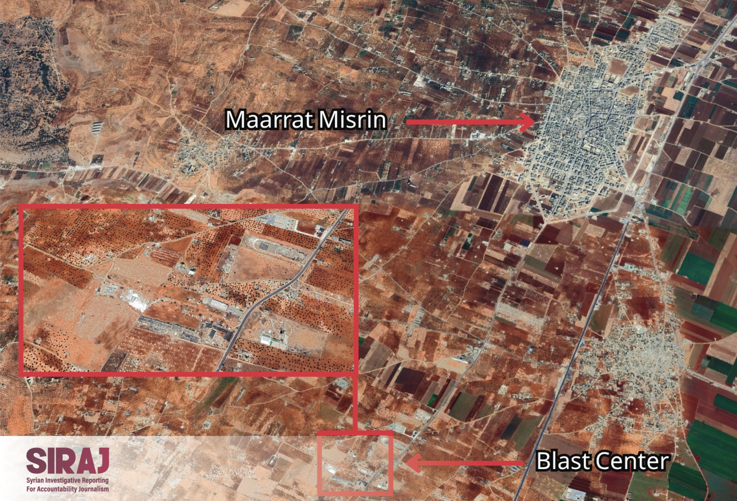
Location of the ammunition depot explosion south of Maarat Misrin in the Idlib countryside. Source: Maxar.
Less than a month after the Maarat Misrin explosion, another weapons storage facility near Idlib city exploded on August 14, 2025, killing four people, including two children, and injuring five others, according to statements issued by the Ministry of Emergencies and Disaster Management.
On November 26, 2025, an ammunition depot exploded in the Kafr Takharim area of Idlib governorate.
The explosion killed five people, including women and children, and injured at least ten others, according to the head of the Civil Defence Centre in the Harem district, speaking to Syria’s Al-Ikhbariya television channel.
However, statements made by the director of the Harem district to Al Jazeera contradicted this account. He said that those killed were members of the Syrian Ministry of Defence.
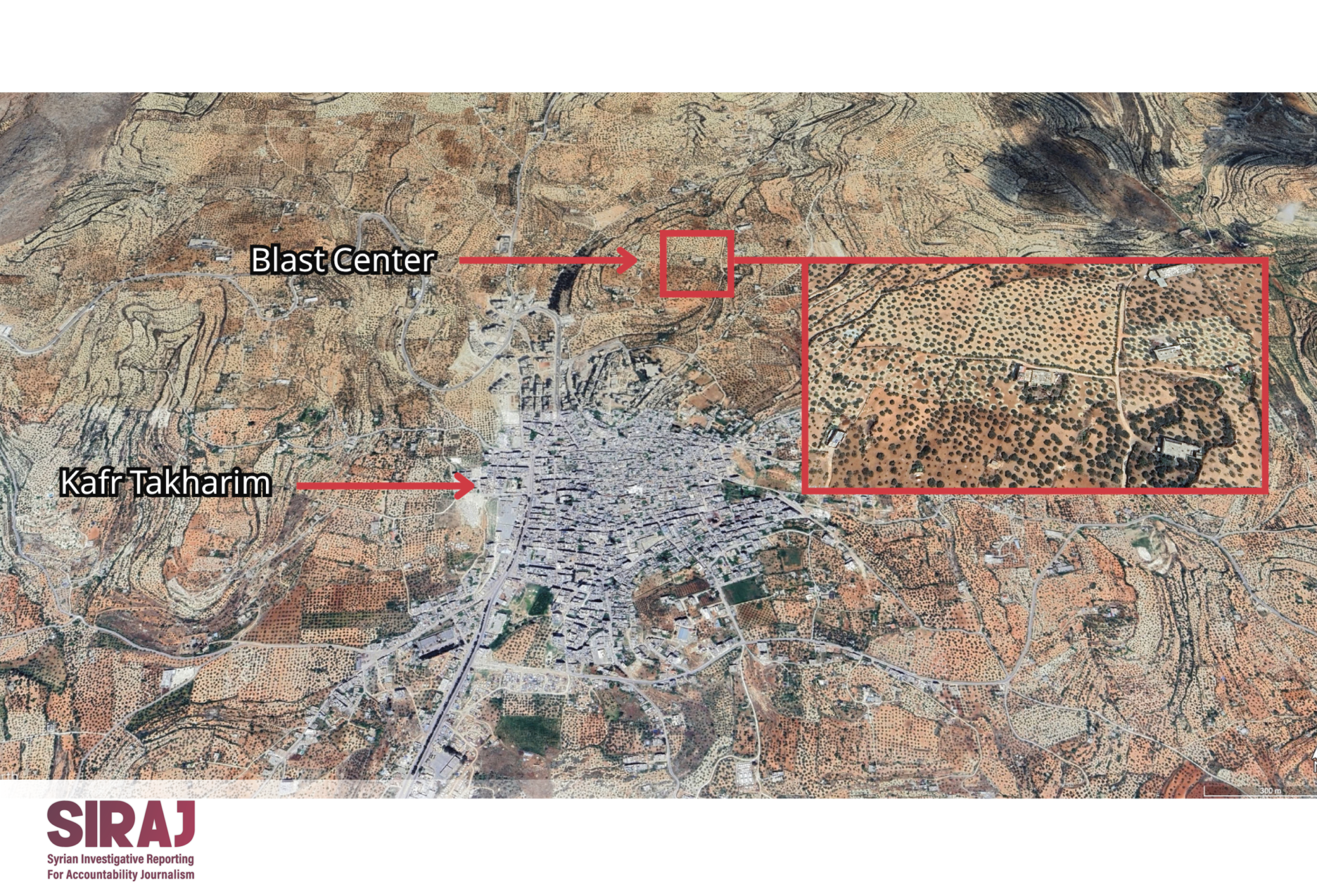
Location of the ammunition depot explosion north of Kafr Takharim in the Idlib countryside. Source: Maxar.
September 2026 saw a significant increase in both the number and frequency of explosions associated with ammunition storage facilities across Syria.
On September 1, 2026, a vehicle transporting ammunition exploded in the Binnish area of rural Idlib, killing five people and injuring others, according to information provided by the Idlib Health Directorate to Syria’s Al-Ikhbariya television channel.
Just over a week later, on September 9, 2026, a temporary weapons storage facility exploded in the Burj Al-Nimra area near Sarmada, killing 14 Ministry of Defence personnel and injuring ten people, including civilians.
Three days later, on September 12, an ammunition depot in the Al-Dumayr area of the Damascus countryside exploded. A security source told Syria’s Al-Ikhbariya channel that the depot contained ammunition “left behind by the former regime.” Several sources reported that the damage was limited to property.
On September 18, eleven members of the Syrian Ministry of Defence were killed when a ministry-affiliated weapons depot exploded in the Ayyash area of Deir ez-Zor governorate.
While the families of the Ayyash victims were still receiving condolences, news broke of another explosion in the town of Al-Eis, south of Aleppo.
This brought the number of weapons and ammunition depot explosions recorded within a single month to five.
Lasting Damage
Beyond the devastating human toll of explosions at weapons and ammunition storage facilities in Syria, the damage extends to civilian buildings and infrastructure surrounding the blast sites.
This places residents and those who depend on these facilities at risk of long-term consequences if urgent reconstruction and repair measures are not undertaken.
The SIRAJ team examined ten locations where weapons or ammunition storage facilities had exploded across Aleppo, Idlib, Deir ez-Zor and Rural Damascus governorates.
By comparing satellite images taken before and after the explosions, the investigation identified the destruction and damage inflicted on surrounding residential areas and civilian infrastructure.
In Kafr Takharim, satellite imagery captured between November 20 and 27, 2025, before and after the November 26 explosion, reveals damage to agricultural areas surrounding the blast site.
These areas include numerous residential houses and farms. The images also show the collapse of the building that had been used to store ammunition.
In Maarat Misrin, which witnessed one of the deadliest explosions, killing 11 people and injuring 157 others, satellite images captured between July 23 and 27 show damage to homes and farms surrounding the explosion site.
The affected area contains several commercial farms and civilian residences.
Satellite images of Al-Eis in Aleppo governorate, captured between September 16 and 21, also reveal extensive destruction at the explosion site, where several people were injured.
The affected area contains several commercial farms and civilian residences.
Satellite images of Al-Eis in Aleppo governorate, captured between September 16 and 21, also reveal extensive destruction at the explosion site, where several people were injured.
An Imminent Threat
Although the circumstances and locations of weapons and ammunition depot explosions in Syria since 2025 have varied, as have assessments of their causes, ranging from improper storage and lack of expertise to possible deliberate acts, most of these incidents share one particularly significant characteristic: their proximity to civilian areas.
The SIRAJ team analysed satellite maps after identifying the precise locations of ten explosions at weapons and ammunition storage facilities, measuring their distances from surrounding civilian areas, public services and infrastructure.
The journalists also analysed photographs and videos providing close-up views of the explosion sites, published by state media, Civil Defence forces and the Ministry of Emergencies and Disaster Management.
The analysis revealed an absence of protective structures or blast barriers, which are normally used even in basic above-ground ammunition storage arrangements.
According to the United Nations' International Ammunition Technical Guidelines, the minimum separation distance between small ammunition storage facilities containing less than 500 kilograms of ammunition and civilian areas should range from 120 to 180 metres when protective barriers are present, and from 270 to 400 metres when such barriers are absent.
These distances are directly related to the amount of ammunition stored at each facility.
As the quantity increases, the required safety distance also rises, exceeding 1.5 kilometres in some cases. The type of ammunition stored can further increase the required separation distance.
For its analysis, the investigation team selected the minimum storage safety scenario, involving ammunition facilities containing no more than 500 kilograms and lacking protective earth berms.
Using this reference scenario, the team examined a circle measuring 400 metres in diameter around each explosion's centre to estimate the extent of civilian areas and facilities potentially exposed to danger during previous incidents.
How We Conducted the Analysis
The SIRAJ team identified the centre of each explosion by matching published photographs and videos from the incident locations with landmarks visible in satellite imagery.
The team then compared images captured before and after each explosion to identify the building or area showing the most significant change, such as the collapse of a structure, burn marks, or displaced materials surrounding the weapons storage site.
Where it was not possible to determine the exact centre of an explosion, the team used the centre of the visible damage area as an estimated incident location, applying a spatial margin of error of ±30 metres.
The distances between these points and surrounding civilian structures were then measured using the distance and area measurement tools available in Google Earth.
To compare the sites with United Nations standards, the investigation adopted a low-end reference scenario involving a storage facility containing 500 kilograms of Net Explosive Quantity (NEQ).
NEQ refers to the actual weight of explosive material contained within ammunition, rather than the total weight of shells, containers or packaging materials.
For analytical purposes only, the team treated the ammunition as belonging to Hazard Division 1.1 (HD 1.1), a classification associated with the risk of mass explosion.
This assumption was necessary because the team was unable to obtain official information identifying the types and quantities of ammunition stored at each location.
Satellite imagery alone cannot determine the actual quantity of explosives stored at a facility, their precise classification, the thickness of walls, the internal design of structures, or the presence of underground fortifications.
Nor can satellite imagery establish the actual reach of fragments or blast waves following an explosion.
For this reason, the distances used in the investigation represent a comparative reference scenario rather than an estimate of the actual blast radius of each incident.
Because SIRAJ was unable to obtain official data on the Net Explosive Quantity or hazard classification of ammunition at each site, the investigation does not present the 400-metre zone as an estimate of the actual blast radius.
Instead, the team used this distance as a consistent benchmark based on one of the above-ground storage scenarios for HD 1.1 ammunition containing a Net Explosive Quantity of 500 kilograms, as outlined in the International Ammunition Technical Guidelines (IATG).
The required separation distances may be greater or smaller depending on the quantity and type of explosives, the design of the storage facility, protective barriers and the surrounding environment.
Speaking to SIRAJ, Nawar Shaaban Qabaqibo, a researcher at the Arab Center for Contemporary Syrian Studies, explained that international standards at every level follow a fundamental principle: weapons and ammunition must not be stored near civilian areas.
This principle is intended to protect civilians from the consequences of accidental explosions or military strikes during armed conflicts.
He added that different types of ammunition may require considerably greater separation distances from civilian areas.
This is particularly relevant to Grad rockets, whose rocket motors can contribute to the spread of explosive fragments over distances of several kilometres.
The investigation team also reviewed its methodology for assessing the scale of explosions with Qabaqibo.
He cautioned that examining explosions in Syria within a 400-metre zone might not adequately reflect the actual scale of the danger.
Many ammunition depots in Syria contain tonnes of weapons and ammunition, he noted, meaning the risks posed by these explosions may extend well beyond the minimum storage safety distances established under United Nations standards.
Qabaqibo also argued that current weapons storage practices in Syria, and the explosions resulting from them, violate Article 58 of Additional Protocol I to the 1949 Geneva Conventions.
He explained that this provision requires military actors to avoid locating military objectives near civilian areas.
The investigation's analysis of the Kafr Takharim ammunition depot explosion, which occurred on November 26, 2025, killing five people and injuring ten others, showed that the identified danger zone encompassed at least 55 civilian buildings, including homes and farms.
This placed at least dozens of residents at direct risk.
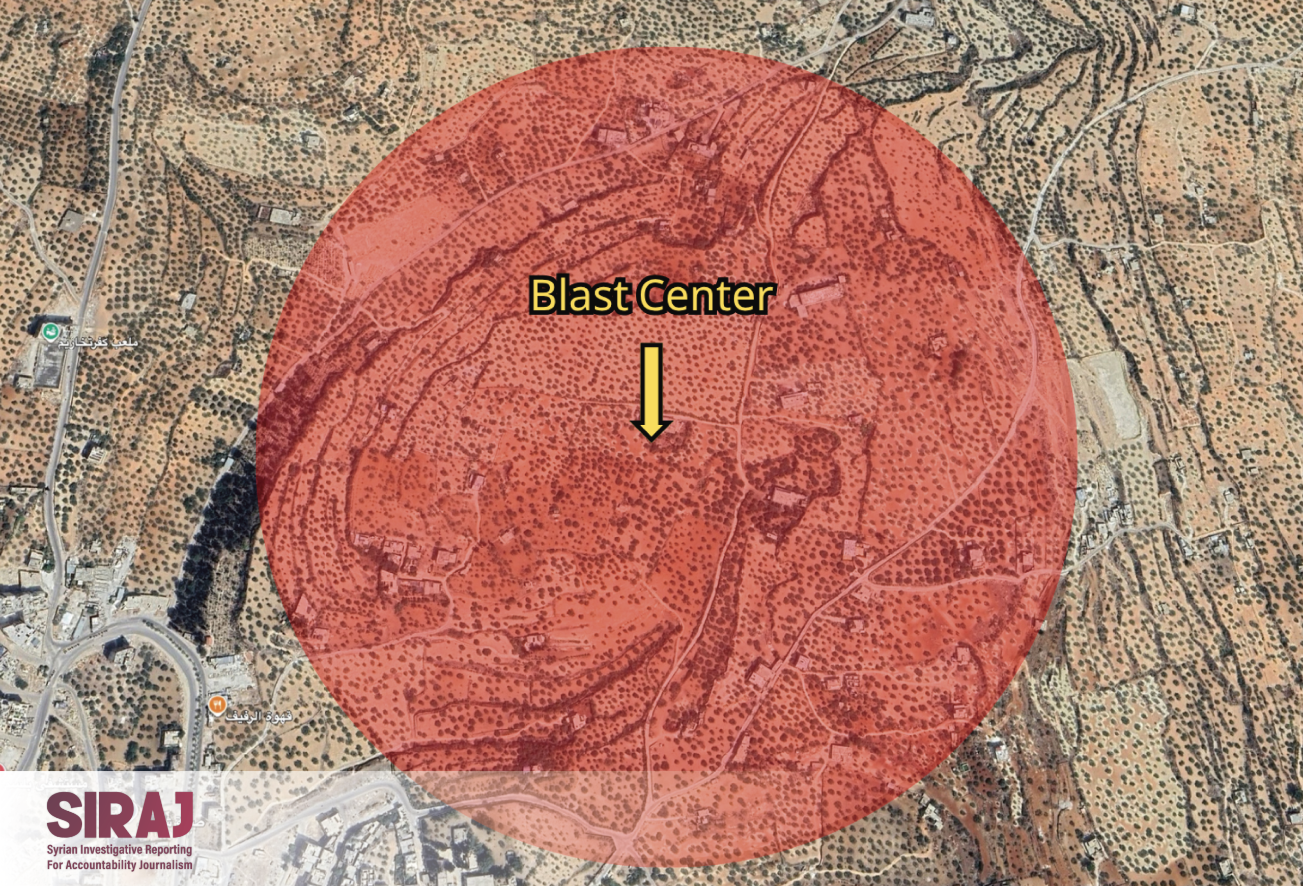
The Kafr Takharim explosion placed numerous homes and farms within a 400-metre zone at direct risk from the blast. Source: Maxar.
In the Al-Nayrab camp area of Aleppo, where an ammunition depot exploded, the facility's location placed at least 150 civilian structures at risk.
These included residential buildings, farms, a mosque and a telecommunications tower.
Given the density of surrounding residential areas, the explosion exposed hundreds of residents to direct danger within the 400-metre perimeter around the blast centre.
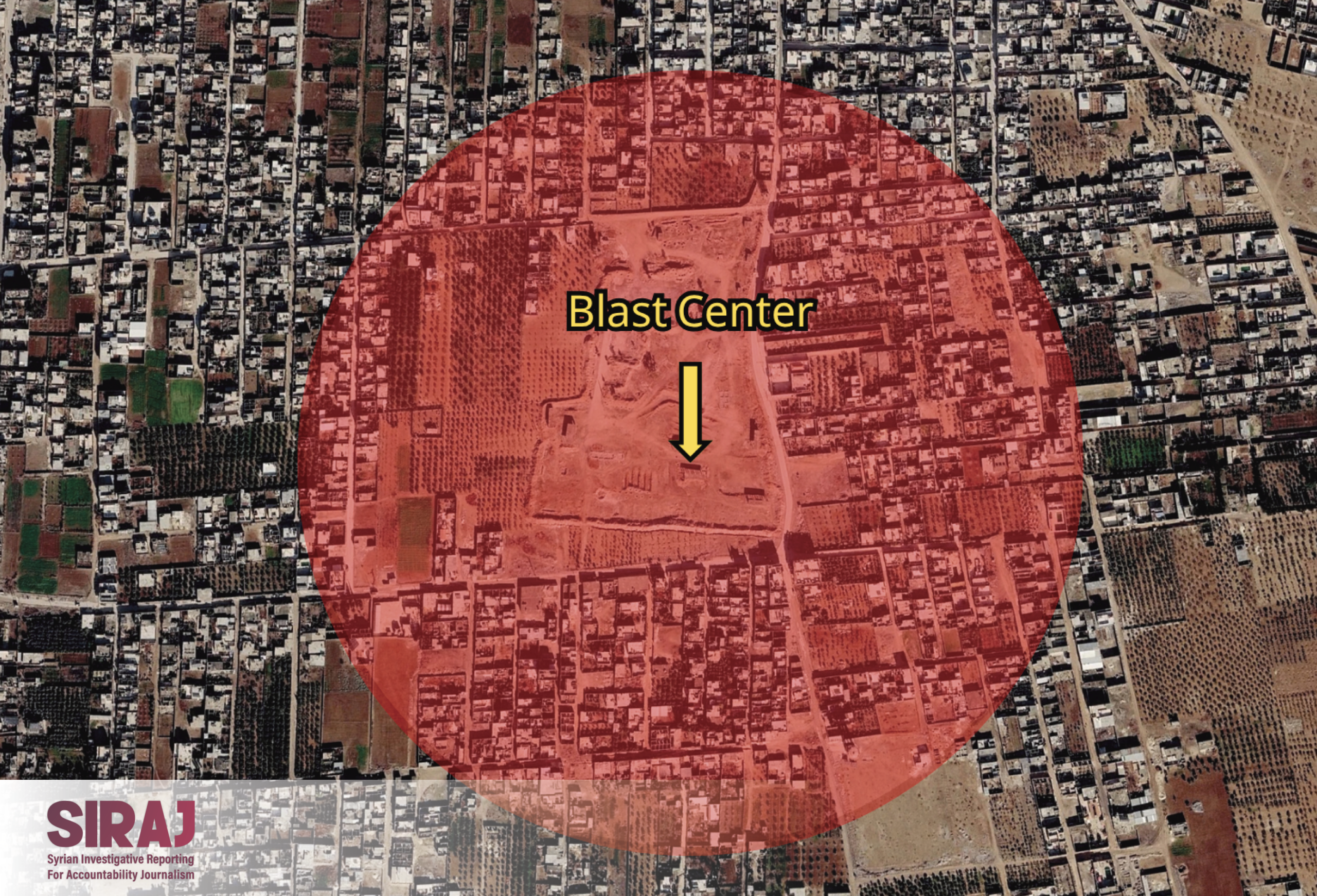
The Al-Nayrab camp explosion directly endangered dozens of residential buildings within 400 metres of the explosion's centre. Source: Maxar.
In Maarat Misrin, where an ammunition depot explosion killed 11 people and injured 157 others, the investigation's analysis identified at least 19 buildings within the danger zone.
These included residential houses, surrounding farms and a plastics factory, all of which were directly exposed to the consequences of the explosion.
The open terrain around the explosion site and the absence of protective earth berms or other protective structures allowed explosive fragments to spread across a wide area, including camps housing internally displaced people.
This contributed significantly to the high number of injuries.
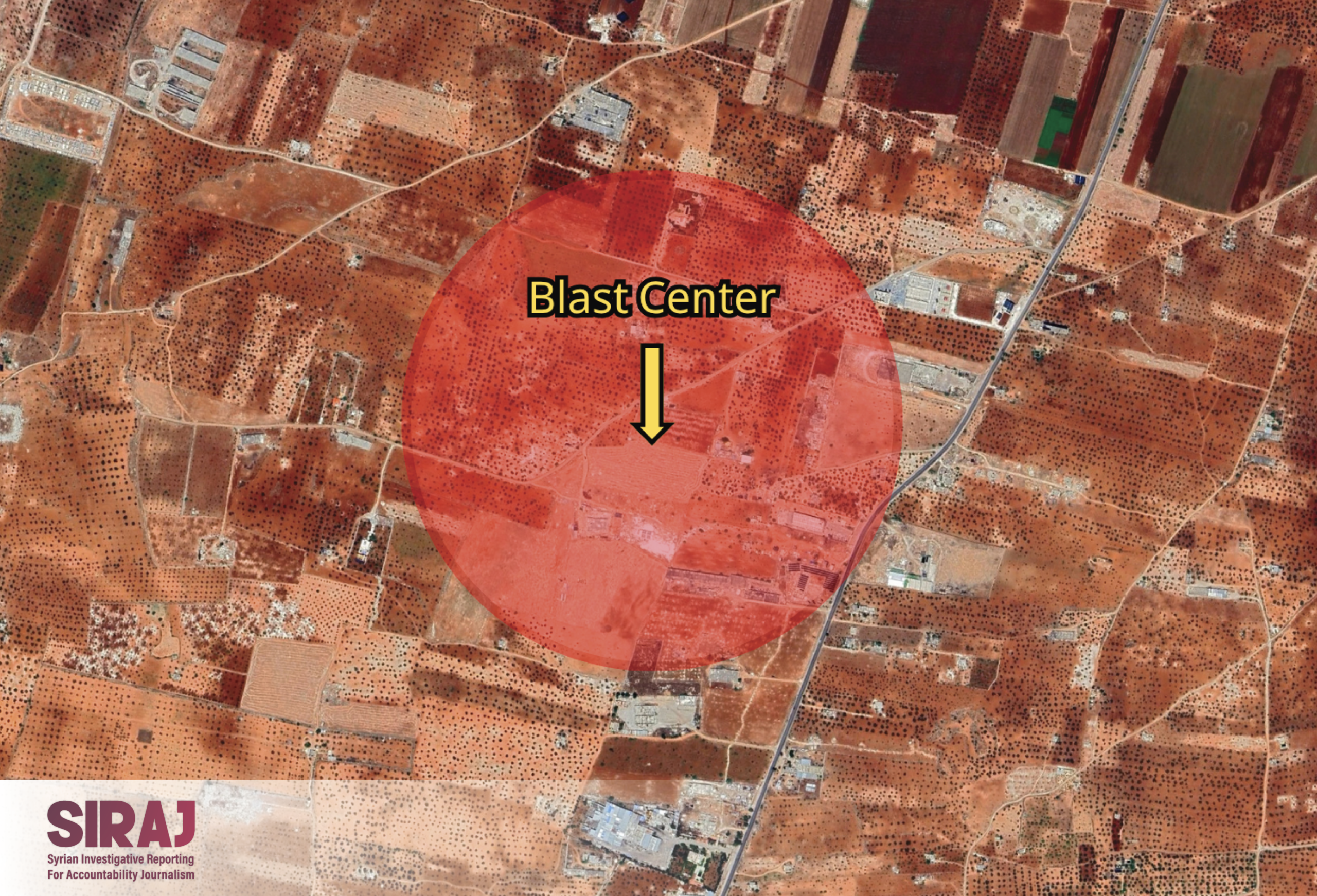
Open terrain allowed the danger from the Maarat Misrin explosion to spread across a wider area, resulting in hundreds of injuries in the surrounding region. Source: Maxar.
After examining all ten explosion sites, the investigation team found that nine had exposed surrounding civilian areas and facilities to direct danger even when assessed against the minimum ammunition storage safety standards.
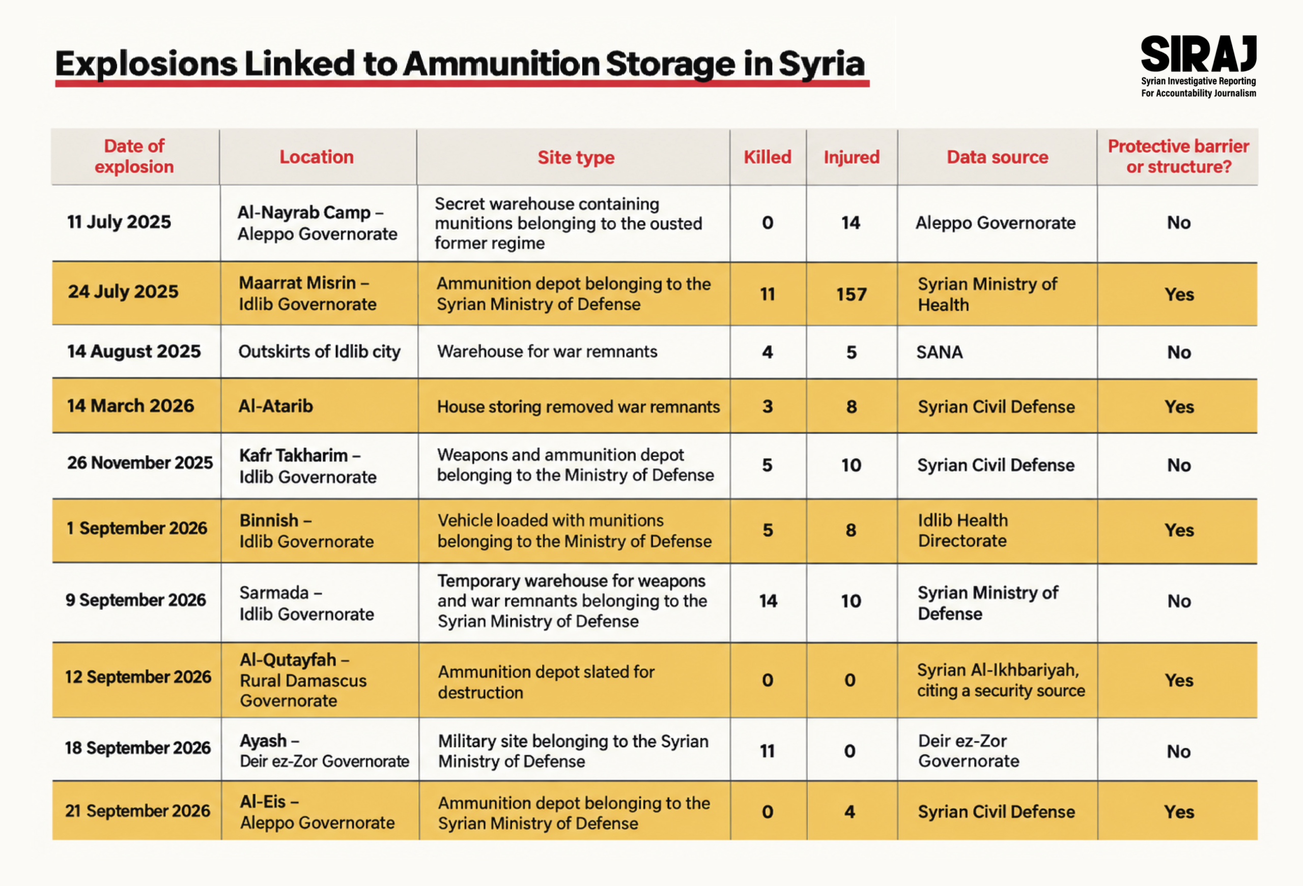
This analysis does not account for the possibility that larger quantities of explosives at individual facilities would require greater safety distances, potentially expanding the danger zone in many cases.
Basic and inadequate weapons and ammunition storage practices in Syria continue to place hundreds of civilians at direct risk in the event of accidents or explosions.
The danger stems from the extremely close proximity of these facilities to civilian areas and infrastructure, compounded by the absence of adequate safety precautions and protective barriers.
Without urgent measures to reinforce ammunition storage facilities or relocate their contents to more secure locations farther from civilian communities, Syria risks experiencing similar incidents in the future, with further loss of life and extensive material damage.
The Syrian Ministry of Defence did not respond to questions submitted by SIRAJ regarding the official procedures followed for weapons storage, whether additional depots remain located in civilian areas, or what safety measures are currently in place.
Creative Direction and Visual Design: Radwan Awad