Since the fall of former President Bashar al-Assad’s regime in December 2024, the issue of landmines has become one of the most complex challenges facing Syrian authorities and organizations working in this field. Minefields and unexploded ordnance (UXO) are widely scattered across Syria, particularly in areas that witnessed frontline confrontations between regime forces, opposition groups, and various armed factions during the years of the Syrian uprising.
One of the most prominent examples is the former frontline south of Idlib Governorate, which separated regime forces from opposition forces led by Hay’at Tahrir al-Sham (HTS). This line extends across large parts of the countryside of Aleppo, Hama, and Latakia. It is considered one of the most heavily contaminated areas with landmines, according to Abdul Razzaq al-Qantar, Director of Victim Support Department at the Syrian Ministry of Emergency and Disaster Management’s National Mine Action Center.
Between 2020 and 2024, the region witnessed thousands of deaths and injuries caused by landmine explosions, reaching around 15,000 cases, according to statements by Maysara al-Hassan, Operations Commander of the Engineering Regiment in the 80th Division of the Syrian Ministry of Defense.
The absence of maps documenting minefields laid during the years of conflict due to the destruction or removal of documents by regime officers responsible for these operations has been one of the main reasons behind the continued deaths and injuries among civilians and demining personnel after the regime’s fall. According to Fadel Abdul Ghany, Director of the Syrian Network for Human Rights, the former regime deliberately left these areas without minefield maps or warning signs to maximize casualties after losing control of them.
A previous investigation published by the Syrian Investigative Reporting for Accountability Journalism – SIRAJ in March revealed a systematic targeting of agricultural areas along the frontline, estimating the cost of mine clearance in the examined area at approximately $137 million (around 15.2 billion new Syrian pounds).
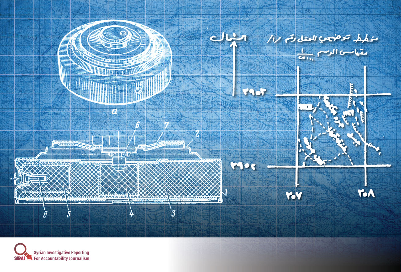
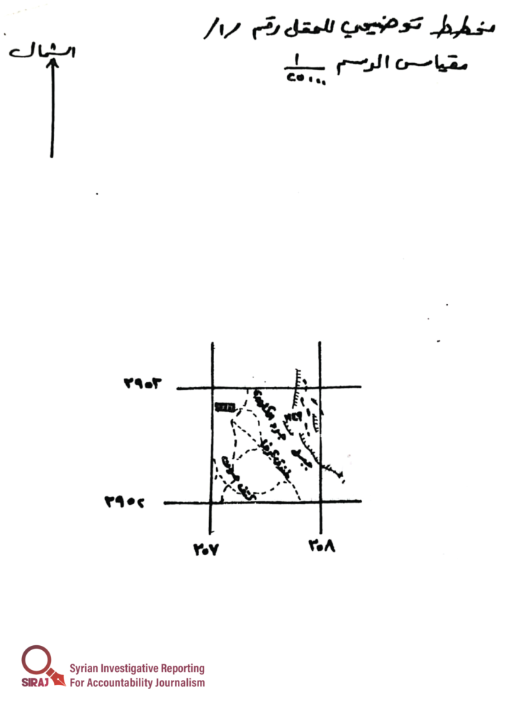
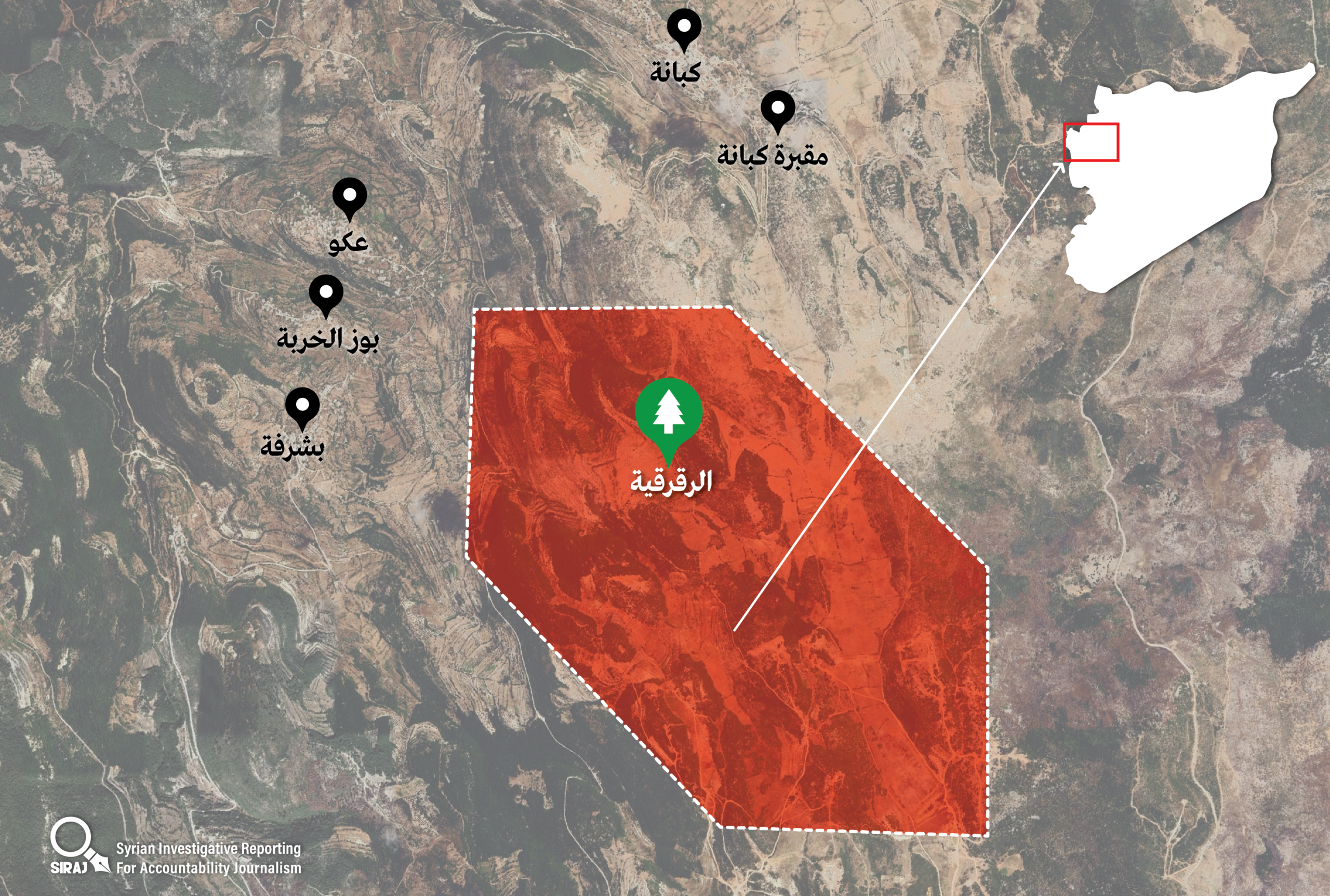
This report, based on open-source intelligence, reveals, through images of hand-drawn maps, a site containing nine minefields. By translating these maps, along with the local mapping systems used by Assad’s forces, into precise coordinates, journalists were able to locate the site in eastern rural Latakia, south of Kabana village. The area spans approximately three square kilometers, yet its threat extends to the lives of residents in several surrounding villages.
SIRAJ’s team reviewed images of nine minefield maps left behind by regime officers after withdrawing from their positions (frontlines) in rural Latakia during the “Deterrence of Aggression” battle in November 2024. The labels on these maps reference several locations in the Latakia countryside, including Kabana village and Jabal al-Zwayqat.
However, unlike standard mapping systems commonly used in modern applications, which rely on latitude and longitude or conventional metric coordinates, the Assad regime’s forces used a different metric system. While globally recognized systems are based on the intersection of the Greenwich meridian and the equator as a zero point, the system used by Assad’s army was a local one with an unknown reference origin. This makes it difficult for conventional mapping systems to interpret the coordinates found on these maps.
In collaboration with experts using open-source techniques, journalists analyzed these maps and converted their locally based coordinate system into globally recognized coordinates that can be accurately identified using publicly available mapping tools such as Google Earth, Google Maps, and Alpine.
We presented the maps to an engineering officer, a colonel in the Syrian Ministry of Defense, who requested anonymity, to understand better why the former regime’s army relied on this type of mapping and its military significance. “The Assad regime used this type of mapping and its own coordinate system,” he explained, “to protect its information, making it more difficult for any group that might obtain these maps to interpret them or dismantle the mines.”
These hand-drawn maps use a scale of 1:25,000, meaning that 1 centimeter on the map represents 25,000 centimeters (250 meters) in reality. For example, if a square marking a minefield on the map measures 4 square centimeters, it corresponds to an area of 250,000 square meters, or 0.25 square kilometers on the ground.
We examined nine maps, each marking one of nine minefields numbered from 1 to 9. By converting the metric coordinates used by former regime officers into global coordinates using specialized techniques, we identified five minefields that form the outer boundary of the contaminated area, in addition to four others located within those boundaries.
The coordinates show that the total area covered by the nine minefields is approximately three square kilometers, equivalent to more than 400 football fields. These minefields span large areas of hills south of Kabana village and southeast of the villages of Aiko, Bouz al-Kharba, and Basharfa in the Latakia countryside areas that continue to experience injuries and fatalities due to landmines.
At the center of the minefield zone lies Raqraqiyeh Park, placing the lives of many families and children from nearby villages at significant risk due to the high density of mines in the area.
The terrain further compounds the danger: the nine minefields are not located at the same elevation, as the area consists of multiple hills of varying heights. The rugged landscape also makes it more difficult for residents to detect mines, increasing the risk of moving through the area.
The exact types of mines deployed by the former regime forces in this area remain unknown, including whether they are anti-personnel or anti-vehicle mines. However, the positioning of these minefields suggests that the regime intended to use them as a first line of defense for its positions in the Latakia countryside if opposition forces advanced beyond the former frontline.
To accurately determine the geographic extent of these minefields on the ground, we identified six key coordinate points that outline the boundaries of the contaminated area, forming a hexagon encompassing the nine minefields. The coordinates are as follows:
35.6898، 36.24565
35.69881، 36.24585
35.70798، 36.235
35.70814، 36.22395
35.69913، 36.22376
35.68996، 36.23461
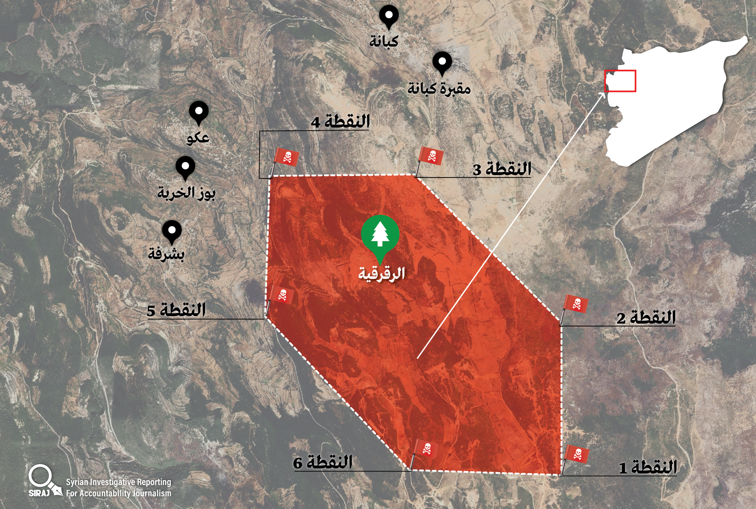
The following map also includes all coordinates of the minefields, along with the surrounding area and nearby villages.
The Colonel added, “Decoding this type of maps is critically important for accelerating demining operations, narrowing search efforts within a clearly defined geographic scope, reducing the number of casualties, and enabling the use of mine-clearing equipment that typically does not rely on precise maps. Most importantly, it helps warn residents in affected areas about the presence of landmines.”
The Syrian Network for Human Rights has documented the deaths of 3,485 people, including 872 children, as a result of landmine explosions between March 2011 and the beginning of this year.
SIRAJ has shared all maps, coordinates, and findings from this report with the relevant Syrian authorities responsible for mine action and UXO.
- Creative direction and visual solutions: Radwan Awad.